Home »

Sage Creek fire mushrooms to 1,016 ha
There is one new wildfire of note in the Southeast Fire Centre.
The Sage Creek wildfire is located in the Flathead area, about 65 kilometres southeast of Fernie and about six kilometres southwest of the B.C.-Alberta border.
Discovered August 2, this lightning-caused fire has mushroomed from 150 ha soon after being found to about 1,016 hectares today, and is producing a large column of smoke that is highly visible from Pincher Creek, Alberta, and surrounding areas.
 The BC Wildfire Service (BCWS) has classified this fire as a modified response fire. That means that the fire is being closely monitored, and a combination of direct and indirect suppression techniques are being used. It is burning vigorously, but in remote terrain.
The cause of this fire is currently under investigation.
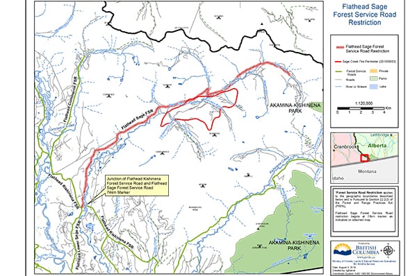
Effective immediately, the Flathead Sage Creek Forest Service Road is closed to traffic starting at the 74-kilometre mark, at the junction of the Flathead Kishinena Forest Service Road and the Flathead Sage Forest Service Road. (See the map above.)
BC Wildfire Service crews are working to reinforce the Flathead Sage Forest Service Road as a fire guard on the north end of the Sage Creek wildfire. The south side of the fire is burning upslope and connecting with the fuel break created by the 2017 Kenow Mountain wildfire.
Winds in the area are expected to shift late this afternoon and direct smoke from this fire south of the U.S. border.
In total, there have been 75 new wildfire starts in the Southeast Fire Centre over the past 48 hours, as a result of recent and ongoing lightning in the region.
The BC Wildfire Service is prioritizing these new fires and responding to them accordingly.
Currently, 109 fires are burning within the Southeast Fire Centre’s jurisdiction. Since April 1, 2018, 245 fires have burned 3,013 hectares. The fire danger rating in the Southeast Fire Centre is currently a mix of “high” and “extreme.”
BCWS reports a new.01 ha fire on Mount Sabine, believed to be human caused, about four km north of Canal Flats.

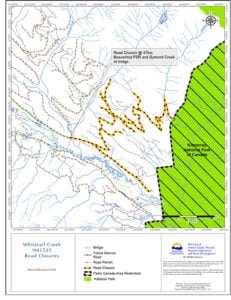
A road closure remains in effect on the Beaverfoot Forest Service Road starting at the 47-kilometre mark (near the Symond Creek Bridge). No access is permitted on this section of road, which is near the Whitetail Creek wildfire, northeast of Spillimacheen, which is considered 25% contained at 300 ha or so in scale.
The BC Wildfire Service reminds the public that a campfire prohibition is in effect for the entire Southeast Fire Centre. Given the current wildfire activity and weather conditions, it is crucial to reduce the risk of human-caused wildfires so the BC Wildfire Service can deal with new naturally occurring fires.
Anyone found in contravention of an open burning prohibition may be issued a ticket for $1,150, required to pay an administrative penalty of $10,000 or, if convicted in court, fined up to $100,000 and/or sentenced to one year in jail. If the contravention causes or contributes to a wildfire, the person responsible may be ordered to pay all firefighting and associated costs.
For more information about current bans and restrictions
To report a wildfire or open-burning violation, call 1-800-663-5555 toll-free, or *5555 on a cellphone. For the latest information on current wildfire activity, burning restrictions, road closures and air-quality advisories, visit: http://www.bcwildfire.ca
e-KNOW


