Home »

High wildfire alert due to heat and storm threat
With the hottest day of the year behind us, the East Kootenay remains on high alert for wildfire danger with a severe thunderstorm watch underway and wind gusts up to 70 km/h possible.

The fire west of Ta Ta Creek, which has prompted an evacuation alert for 121 properties in the area, has been renamed the Lost Dog Complex.
It includes four fires with a combined area currently estimated at 165.5 hectares. BC Wildfire Service (BCWS) has 26 personnel, two helicopters and six pieces of heavy equipment on the fire today. The fire is in the Lost Dog area and is approximately seven km northwest of Ta Ta Lake.
A severe thunderstorm watch has been issued for the entire East Kootenay by Environment Canada and it expected to be a windy day.
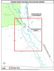
The Cross River wildfire, discovered August 1, which has forced the Regional District of East Kootenay to issue an evacuation order for eight properties in the area 25 km east of Radium Hot Springs, is now 36.4 ha in scale. The evacuation order includes Nipika Mountain Resort.
“This fire is a modified response fire meaning it is managed using a combination of suppression techniques, including direct and indirect attack, and monitoring to steer, contain and otherwise manage fire activity within pre-determined perimeters,” BCWS reported this morning, noting five firefighters are on scene of the lighting-caused wildfire.

The Cross River Forest Service Road is closed starting at the 16 kilometre mark running to the Cross Mitchell River Forest Service Road and the Cross River Forest Service Road. This road closure applies to all non-industrial road traffic.
“This fire is burning in steep and difficult terrain and is being closely monitored. Crews continue to build guard on the south flank with the aid of heavy equipment,” BCWS said.
The person-caused fire up Coal Creek, about 13 km east of Fernie, remains at 20 ha, BCWS reports.
The Sage Creek wildfire 65 km south of Fernie is 1,148 ha today with 76 firefighters, seven helicopters, three pieces of heavy equipment and two airtankers attacking it.
This fire is burning in remote terrain. Crews are working to reinforce the Flathead Sage Forest Service Road as a guard on the north end of the fire. The south side of the fire is burning upslope and connecting with the fuel break created from the Kenow Mountain wildfire from 2017.
Crews are planning for future burn off operations. Expect to see additional smoke from this fire in the coming days.
“Crews and equipment continued to build guard on the east and west sides of fire along perimeter. Bucketing and airtanker drops continued in priority areas. Heavy equipment will continue constructing dozer lines. Crews will provide support with pump and hose; mop-up continues on southwest side. Aerial suppression will continue to limit further spread along the perimeter,” BCWS reported.
Whitetail Creek remains a wildfire of note, at 282 ha in size and 35% contained and 50% guarded. Today there are 51 firefighters, three helicopters and four pieces of heavy equipment on scene.
“Crews are reinforcing machine guards and extinguishing hotspots to limit fire growth. Air resources continue to bucket hotspots,” BCWS said.
Other fires in the region
- The Akenside Creek west of Edgewater remains active at 133.8 ha.
- The Bull FSR fire, believed to be human-caused, discovered August 7, is still two ha in scale according to the BCWS.
“With increasingly hot and dry weather, wildfires can change rapidly. If you are planning to enter the backcountry, please maintain situational awareness of existing wildfires and avoid areas with active firefighting operations,” BCWS asks of the public.
Environment Canada reports there is a 60% chance of showers this afternoon, with late afternoon/early evening thunderstorms possible.
e-KNOW


