Home »

Wildfire update for the East Kootenay
The following is an update on wildfires burning in the East Kootenay, compiled from the most recent updates from BC Wildfire Service (BCWS).
Lladnar Creek Wildfire
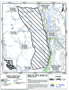
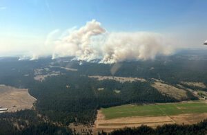
Discovered on Friday, July 21, the fire looming beside the District of Sparwood is now 343 hectares.
BC Wildfire Service this afternoon (July 27) reports the fire is a smouldering ground fire (rank 1 and 2) with pockets of rank 3 in areas of heavy fuel accumulation. Learn more about wildfire rank.
 “Temperatures Thursday are expected to range from 27 to 32 C. Winds are forecast to be variable from 8 to 18 km/h with gusts of 20-30 km/h. Relative humidities are low and a risk of thunderstorms is present across the fire centre. Winds accompanying thunderstorms may be stronger and erratic. Temperatures are expected to be hotter on Friday, which also brings a heightened risk of thunderstorms and lightning,” BCWS reports.
“The fire is reaching to machine guard that runs parallel to transmission lines at the bottom of the slope and crews will continue to do small-scale hand ignitions to anchor it to the guard. This tactic removes unburnt fuel between the fire edge and control lines in an intentional manner to reduce the chance of the fire spreading beyond control lines. Small-scale planned ignitions began Wednesday and will continue Thursday and in coming days if and when conditions are favourable.
“On Thursday, heavy equipment continues pushing machine guard south toward Lladnar Creek and north above Sparwood Heights to Cummins Creek. Firefighters are also establishing water-delivery systems and hoselay in critical areas.
“Structure protection personnel are on site, assessing properties and developing plans to install equipment as a precautionary measure if needed in Sparwood Heights and other areas of concern.
“Aircraft are assisting ground crews on Thursday as needed to cool the fire’s edge and slow growth downslope as firefighters and heavy equipment construct guard to help prevent spread toward the community. Helicopters will bolster those efforts where it is safe and effective to do so.”
There are 45 personnel responding to this fire.
There are currently four helicopters shared between this incident and the St. Mary’s River wildfire.
There are eight pieces of heavy equipment assigned to this wildfire.
There are 69 structure protection personnel responding to this incident and the St. Mary’s River wildfire.
Evacuation Orders and Alerts
The District of Sparwood has issued an evacuation ALERT due to this wildfire. For the latest information on evacuation alerts and orders, visit the District of Sparwood website.
The BC Wildfire Service recommends evacuation orders or alerts to local governments based on areas of potential concern after considering a number of factors including: site conditions and weather, current and forecast fire behaviour and the presence of natural containment features.
Currently, wildfire officers on the Lladnar Creek wildfire have recommended evacuation alerts only for the area of Sparwood Heights south of Sparwood Heights Drive along with residences on Matevic Road. This is due to these areas being in closest proximity to the fire and most likely impacted in the event of unexpected downslope growth over containment lines. Wildfire officers continue to monitor fire progression and will extend alerts if weather, fire behaviour and forecasted fire growth render it necessary.
While the BC Wildfire Service recommends evacuation orders and alerts, local authorities are responsible for implementing them. For more information on the evacuation alert due to the Lladnar Creek Wildfire, visit the District of Sparwood website
Evacuation alerts mean you may need to evacuate, sometimes with little or no notice. An evacuation alert is the time to get prepared by, for example, putting essentials in a “grab-and-go” bag and planning accommodation should you need to leave your home. More information on evacuation preparation and emergency planning is available at www.preparedbc.ca.
Bruce Mountain (Horsethief) Wildfire

Discovered Monday, July 24, the fire is now 1,020 ha.
“Ground crews and aviation resources are making progress on control lines to contain the fire. Heavy equipment is pushing machine guard on the east flank. BC Hydro is on site working to protect its infrastructure,” BCWS reported this afternoon.
“Structure protection personnel, working with local fire departments, are on site to conduct assessments and set up and install equipment as required in areas of potential concern. This fire will continue to be highly visible to the surrounding area.
On Thursday, there is potential for thunderstorms bringing dry lighting and gusting winds.
The Regional District of East Kootenay has issued an evacuation ORDER and ALERT as follows.
There are 26 personnel responding to this fire.
There are currently five helicopters and two airtankers responding to this wildfire.
There are currently seven pieces of heavy equipment responding to this wildfire.
St. Mary’s River Wildfire

Discovered Monday, July 17, the fire remains at 4,093 ha. The fire has not grown since Saturday morning (July 22).
On Thursday, fire activity remains observed as a smouldering ground fire (rank 1). All control lines continue to hold, BCWS reported today.
Temperatures are expected to range from 27 to 32 C. Winds are forecast to be variable from eight to 18 km/h with gusts of 20-30 km/h. Relative humidity is low and a risk of thunderstorms with lightning and little precipitation is present across the fire centre. Winds accompanying thunderstorms may be stronger and erratic.
Friday is forecast to be hotter, with a heightened risk of thunderstorms and lightning.
In the days to come, the BC Wildfire Service will be working with local governments on the process of reviewing and lifting evacuation alerts and orders as soon as it is safe and practical to do so, it noted.
“On Thursday, firefighters are working to secure guard along the fire’s eastern edge using small-scale hand ignitions. Elsewhere on the fire, crews continue to patrol and extinguish hotspots where they occur.
“Crews previously noted some creeping ground fire in the area of the Airport Pasture prescribed burn to the southwest corner of the fire and to the southeast in the area of a 2017 wildfire. Crews are taking the opportunity to do some small-scale hand ignitions on pockets of fuel in the area.
“These small-scale planned ignitions began Wednesday and will continue Thursday as conditions permit. These operations, conducted by hand, remove unburnt fuel between the fire edge and guards in an intentional manner to reduce the chance of the fire spreading beyond control lines. Hand ignitions will be ongoing in the coming days when conditions allow. Intermittent increased smoke will be visible to the surrounding communities during these operations,” BCWS explained.
There are 150 firefighters responding to this incident.
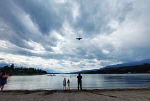
There are currently four helicopters assigned to this wildfire and the Lladnar Creek wildfire. Helicopters will use different bodies of water to gather water for response. Please be mindful and steer clear of aircraft if you see them.
There are currently 13 pieces of heavy equipment responding to this wildfire.
Sixty-nine structure protection personnel are shared between this incident and the Lladner Creek wildfire.
More information on these operations can be found in an operational update with Incident Commander Daniel Klein and Loree Duczek, recorded July 25 at 11:45 a.m. MST. View the video update here.
Evacuation ALERTS and ORDERS for The ʔaq’am community have been updated as follows.
The Regional District of East Kootenay has an evacuation ALERT in effect as follows.
The City of Cranbrook has implemented an evacuation ALERT for the Canadian Rockies International Airport.
Yearling Creek Wildfire
 Discovered Sunday, July 9, the Yearling Creek Wildfire is 1,175 as of today.
The Yearling Creek wildfire, about 25 km east of Radium Hot Springs, is receiving a modified response.
“This means personnel are using a combination of suppression techniques, including direct and indirect attack as well as monitoring to steer, contain and otherwise manage fire activity to minimize damage while maximizing the benefits of fire on natural ecosystems,” BCWS explained.
“Personnel and heavy equipment are making progress putting in guard lines and tying into the Yearling Creek drainage to prevent the fire from coming into closer proximity to properties and other values. Structure protection specialists are on site Wednesday to assess and, if required, install structure protection equipment. Danger tree specialists are assessing and falling danger trees as required.
“Crews will be looking for opportunities to conduct small-scale hand ignitions to remove unburnt fuel between the fire edge and control lines in an intentional manner to reduce the chance of the fire spreading. These small-planned ignitions may begin Wednesday if conditions are favourable. Hand ignitions will be ongoing in the coming days when conditions allow. Learn more about planned ignitions here.”
Evacuation Orders and Alerts:
The Regional District of East Kootenay has implemented an evacuation ORDER and an evacuation ALERT. For more information on the order visit the RDEK website.
Click here for the most recent BC Wildfire Service updates on wildfires in the region and B.C.
e-KNOW


