Home »

Hazard Guidance Project seeks further public consult
By Erin Knutson
The Fairmont Hazard Guidance Project, a collaborative effort between the Regional District of East Kootenay (RDEK), BGC Engineering (BGCE), Pinna Sustainability (PS), and the RDEK Planning team, continues to seek public input. This input is crucial in determining the best policies to govern land use and development for specified hazardous zones in Fairmont Hot Springs and the area.
A Zoom presentation was hosted by RDEK Planner Justin Cook on October 31, which included an in-depth scientific overview of the risks specific to Fairmont Creek and Cold Spring Creek. A team of engineering and planning experts from BGCE, PS, and the RDEK who attended the event along with Area Directors Susan Clovechok (Area F) and Roberta Schnider (Area G), enabled the public to ask questions and offer feedback on the $10 million undertaking fully funded by a Union of BC Municipalities (UBCM) grant to determine best policies for a hazard guide.
“Mountains are living, breathing landscapes with the ability to transport sediment at appreciable volumes,” said BGCE Principal Engineer Brett Eaton.
According to Eaton and collaborators, creating awareness about risk and risk mitigation in these vulnerable areas is crucial to adequately informing residents and determining the best course of action regionally and locally in prevention, emergency preparedness, and infrastructure planning.
During his presentation, Eaton comprehensively examined three types of floods: floods, debris floods, and debris flow. Debris flow is the most threatening to residents near or on the impact zones.
“This is an event that will likely occur only twice in a century,” he said of the probability of a loss of life event, explaining that the risk increases with the length of time a resident inhabits a sensitive area.
According to Eaton’s explanation, the nature of hazards and devastation vary. For example, he described a life-threatening event in the case of a large debris flow.
 “Debris flow is a landslide, an avalanche at the top end of a watershed that comes down during a big rainstorm and hits the stream channel itself. It shocks the stream and generates a flurry of sediment, like concrete; it liquefies and starts moving downstream; if it is a big eruption and moving fast, it will not be possible to escape from it. Eventually, it fans out, eroding and transporting sediment and debris and depositing material around the area’s infrastructure, or housing.”
Eaton explained risk as a human problem that occurs naturally in the landscape but becomes an issue if it impacts people. “It’s human proximity to hazard that results in risk.”
Forming a hazard guide with public involvement to help mitigate these risks is part of this complex project’s strategy. Getting the residents engaged was a point of emphasis during the meeting.
“We want to avoid creating new risk and manage existing risk, reduce hazard through the construction of risk mitigation infrastructure on creeks and inform land use in hazard areas to reduce vulnerability – establishing a good policy to build resilience,” said PS Senior Associate, Resilience and Adaptation Tasmin Mills, who outlined an example of how the Fraser Valley Regional District (FVRD) addressed climate and landscape challenges in its policies.
“The FVRD will evaluate buildings and set the structures back to provide space between a source of potential hazard. They employ monitoring devices and evacuation procedures, raising and reinforcing foundations to reduce risk.”
Questions arose from the public regarding the timeframe for completion of this project.
According to RDEK staff, this project’s timeline is contingent on closing the public feedback period, bylaws aligning with policy development as it emerges, and other factors inherent in integrated planning at this level.
The policy is open to public input through the RDEK website Fairmont Hazard Guidance Project | Engage East Kootenay until Friday, November 29.
All feedback will be considered and incorporated into the policy development process as the developers move forward to complete the hazard guide as quickly as possible.
“This is a $10 million complex project, and reasonable delays happen with a project of this size. We want to focus on getting it done efficiently and making sure the product we receive is the product we want,” said RDEK Engineering Tech Kara Zandbergen.
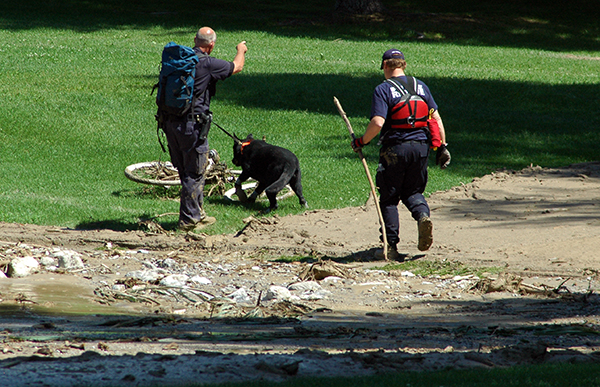
Lead image: Searchers cover Fairmont Mountainside Golf Course after the water, mud and rock debris flow disaster that rolled over part of Fairmont Hot Springs in 2013. The incident led to the ongoing protection work from Fairmont and Cold Spring creeks for the community. Ian Cobb/e-KNOW file photos
e-KNOW


