Home »

Better mapping beefs Doctor Creek wildfire scale

The Doctor Creek wildfire continues to burn 25 kilometres southwest of Canal Flats, now a better-estimated 7,937 hectares, while a fire reported over the weekend near Fort Steele has been quickly brought under control.
The BC Wildfire Service (BCWS) today (August 8) reports a small rainfall helped lower fire behaviour.
“Fire behaviour on the southeast flank will be relatively lower over the next few days as parts of the area received up to 10 millimetres of rain. Crews are working to complete a fuel free buffer zone on the southeast flank in preparation for a planned ignition that will secure this perimeter of the fire. Heavy equipment continues to build a contingency line along the south flank of the fire to further secure the area,” BCWS stated.
“On the northern flank crews continue to extinguish hot spots and patrol the area within 100 feet of the fire perimeter.
“Topographical features on the Doctor Creek wildfire align with winds in such a way that causes it to accelerate as it travels through the valley. As a result, wind speeds on-site are regularly higher than forecasted. This has posed a challenge on the southeastern flank where steep slopes and rocky outcrops are heavily exposed.”

Ground crews continue to work with the support of aviation and heavy machinery. Resources on the fire today include: 185 firefighters; six helicopters; and 13 pieces of heavy equipment.
BCWS said the uptick in fire growth is more due to an accurate track of the fire perimeter being completed. “Growth is due to more accurate mapping.”
A high-pressure ridge should maintain dry and mainly sunny conditions today (Sept. 8).
Temperatures were near freezing overnight with highs in the upper teens and low 20s expected by this afternoon.
A warming ridge will gradually bring mainly sunny skies by Wednesday into Thursday. Conditions on-site will remain dry with low relative humidity.
The Regional District of East Kootenay (RDEK) has expanded the Evacuation Alert area on the Doctor Creek wildfire. For the most up-to-date information regarding evacuation alerts and orders related to this fire, please visit the RDEK > Evacuation Alerts & Orders.
“No structures are currently threatened. Structure protection systems are in use near the fire as a precautionary measure. Where they are no longer necessary, additional structure protection units will be removed over the coming days,” BCWS said.
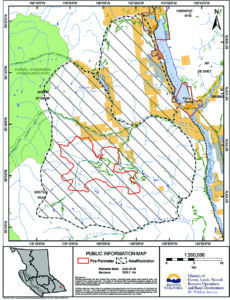
The BC Wildfire Service has reduced the size of the area restriction order for Crown land in the vicinity of the Doctor Creek wildfire, discovered August 18.
The area restriction applies to Crown land within the boundaries as outlined on this map.
The area restriction is in place to accommodate response operations, ensure the safety of firefighters and protect public safety. Road closures and area restrictions are subject to change depending on fire activity. For detailed information about the restriction, visit bcwildfire.ca Information Bulletins – Changes made to the Doctor Creek Area Restriction.
Cooler temperatures and rainfall Sunday night and Monday morning has helped keep the fire count in the East Kootenay down, with only one new fire over the Labour Day long weekend.
That fire, in the Innis Springs area, is about seven km north of Fort Steele, to the east of Bummers Flat.
Considered person-caused, the fire was rapidly and heavily bombed and is now considered under control at .75 ha.
BCWS is still reporting three older fires on its website activity site – all under control, including the fire found Sept. 5 along Highway 95 between Kimberley and Marysville (.10 ha), along with the Booth Creek fire north of New Lake (3.07 ha) and the Stirton Road fire near Marysville (3.5 ha).
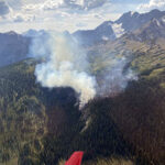
Lead image: Results of a planned ignition to help battle the Doctor Creek wildfire by BCWS personnel on Sept. 4. BCWS photo

e-KNOW


