Home »

Nine wildfires of note burning in region
The BC Wildfire Service (BCWS) is currently battling nine wildfires of note in the East Kootenay, with one causing an outstanding evacuation order at Cross River and four more creating evacuation alerts (St. Mary Valley, Ta Ta Creek, Corbin and one property near Yahk).
Here is a summary of the fires of note as per BCWS’s active wildfires website.

Lost Dog Complex (formerly Ta Ta Creek)
Approximately 14 kilometres north of Kimberley, this fire discovered August 10 has caused an evacuation alert by the Regional District of East Kootenay in the Ta Ta Creek area including west of the Kootenay River from 1.5 km south of Farstad Way Road to 2.5 km north of Woods Corner.
The cluster of three fires is now about 452.5 hectares in scale.
Today, 42 firefighters, two helicopters and six pieces of heavy equipment have been battling the fire.
Meachen Creek
Located in Kianuko Provincial Park and Meachen Creek drainage, approx. 10 km southwest of St. Mary Lake, this lightning-caused fire that was discovered August 1 is now 10,000.0 hectares (estimated) and is the cause for an evacuation alert for properties in the St. Mary Valley west of Kimberley.
“The BC Wildfire Service has been actively monitoring this fire with flights twice daily as conditions allow. This fire has grown substantially in recent days due to it merging with another remote wildfire to the south (Mount Dickson); however, there has been little growth on this fire over the past 24 hours due to subsiding winds and cooler temperatures,” BCWS reported August 14.
 “This fire is producing heavy smoke, making obtaining an accurate map of the fire perimeter a challenge from the air. To obtain an accurate perimeter map, we will be utilizing an infrared scan of the fire. This information will help us to continue to develop a strategy to achieve our containment objectives. This fire is burning in steep, rocky and unsafe terrain for ground resources to respond at this time.
“Though this fire is highly visible, at this time, it is still burning remotely. BC Wildfire’s number one priority is public safety and the safety of our crews,” BCWS said.
An evacuation alert has been issued by the RDEK in the St. Mary’s Lake area from the west boundary of the City of Kimberley to the Redding Creek/St. Mary’s River convergence including St. Mary’s Lake Road and Lakefront Road.
This fire is producing heavy smoke and residents of Kimberley and surrounding communities have been experiencing ash fall.
Expanded forest service road restrictions are in effect for the Meachen Creek, Redding Creek, Grey Creek and White Boar forest service roads. Click here for a detailed map.
Beginning at the 31 km mark of St. Mary Lake Road, the Redding Creek forest service road is closed to the height of land, and the 25.3 km mark on the Hellroaring forest service road junction with the St. Mary River Main forest service road. Click here for a detailed map.
“This fire is currently burning in a northeastern direction, down the Meachen Creek drainage. There has been minimal spread of the fire over the past few days due to cooler conditions and lighter winds.
“The BC Wildfire Service is currently developing containment strategies should the fire continue down the Meachen Creek drainage and into safer, more workable terrain. The safety of the residents of the St. Mary Valley remains the first priority for the BC Wildfire Service,” BCWS stated.
Randal Creek
Approximately 17 km southeast of Yahk on the B.C./U.S.A. border, this fire is now about 905 ha.
Discovered Saturday, August 11, this fire has prompted the RDEK to issue an evacuation alert for the Yahk, Meadow Creek Road and Highway 3/95 area.
An area restriction is in effect for the area past the six km mark on the Yahk Meadow Creek Road. Click here for a detailed map.
Today there were 11 firefighters and one helicopter working the fire.
Crews continue to work on containment with the aid of air support.
Leach Creek
Approximately three km north of Mount Taylor and 21 km southeast of Sparwood, this 30 ha fire, discovered Sunday, August 12, is considered 95% guarded.
“This fire is ‘being held’ meaning that sufficient suppression action has been taken that the fire is not likely to spread beyond existing or predetermined boundaries under the prevailing and forecasted conditions,” BCWS reported.
The RDEK has issued an evacuation alert for 10 properties in Corbin as a result of a lightning caused fire in Leach Creek.
The District of Sparwood has issued an evacuation alert in connection with the same fire. The District’s alert area covers the portion of Corbin Road within municipal boundaries and the Coal Mountain Mine property. For more information on this order, please call the RDEK at 250 426-2188 or visit their website at rdek.bc.ca
Nine firefighters were assigned to the fire today.
Coal Creek FSR
Approximately 12 kilometres east of Fernie, the fire discovered August 10 is now 713 ha.
“This wildfire is currently displaying vigorous fire behaviour and is highly visible from Fernie and Alberta. This fire is not currently threatening communities,” BCWS reported.
The Coal Creek Forest Service Road is closed beginning at the 33 km mark. The Leach Creek Forest Service Road is restricted beginning at the junction of Leach Creek Forest Service Road. The Corbin Road, and Morrisey Creek Forest Service Road are restricted beginning at the 0.3 km on Morrisey Forest Service Road, from the junction with Morrisey Road.
Today saw 11 firefighters, one helicopter and five pieces of heavy equipment on the fire.
“Heavy equipment is working on building containment lines on the south side of this fire. A bucketing helicopter is also on site,” BCWS said.
The cause of this fire is currently unknown and is under investigation.
Sage Creek

Located approximately 65 km south east of Fernie and approximately six km south west of the B.C.-AB border, the fire is 1,936 ha.
Discovered August 2, this fire is a modified response fire meaning it is managed using a combination of suppression techniques, including direct and indirect attack, and monitoring to steer, contain and otherwise manage fire activity within pre-determined perimeters. This type of response is used to minimizes costs and/or damage and to maximize benefits from the fire.
This fire is burning in remote terrain. Crews are working to reinforce the Flathead Sage Forest Service Road as a guard on the north end of the fire. The south side of the fire is burning upslope and connecting with the fuel break created from the Kenow Mountain wildfire from 2017.
Today there were 102 firefighters, a dozen helicopters, two airtankers and three pieces of heavy equipment battling the fire.
“Crews and equipment continued to build guard on the east and west sides of fire along perimeter. Bucketing and airtanker drops continued in priority areas. Heavy equipment will continue constructing dozer lines. Crews will provide support with pump and hose; sprinkler line to be set up on east flank. Aerial suppression will continue to limit further spread along the north perimeter. Ignition sites to be identified,” BCWS reported
The Flathead Sage Creek Forest Service Road is closed starting at the 81 kilometre mark at the junction of Flathead Kishinena Forest Service Road and the Flathead Sage Forest Service Road. No access is permitted on this section of road. This road will remain closed until the public is otherwise notified.
Cross River

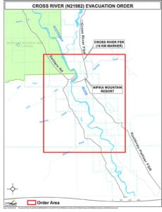
This 2,723 ha wildfire has prompted a RDEK evacuation order the Cross River/Nipika Mountain Resort areas.
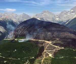
Located approximately nine km east of Highway 93 and Kootenay National Park, the 13-day-old fire is receiving a modified response, “meaning it is managed using a combination of suppression techniques, including direct and indirect attack, and monitoring to steer, contain and otherwise manage fire activity within pre-determined perimeters,” BCWS reported.
Today saw 15 firefighters, a helicopter and four pieces of heavy equipment working the fire, which is burning in steep and difficult terrain and is being closely monitored.
“Crews continue to build guard on the south flank with the aid of heavy equipment,” BCWS said.
Cross River FSR restriction beginning at the 10 km mark of Settler’s Road, continuing down the Ravenheads FSR to the 44.75 km mark and continuing north on the Cross River FSR to the Cross Mitchell FSR junction. The Palliser FSR is restricted from the junction of the Kootenay River/Palliser FSR at the 40.25 km mark, continuing up Palliser FSR to the area around Nipika lodge.
Whitetail Creek
 Located just outside of Kootenay National Park, approximately 40 kilometres north of Radium Hot Springs, the fire discovered July 27 is about 576.0 ha, is 50% guarded and 20% contained.
Today there were 37 firefighters and two pieces of heavy equipment on the fire.
This is a modified response fire. The fire is being managed using direct and indirect attack management tactics and fire behaviour monitoring to contain the fire within pre-determined perimeters. This type of response is used to minimize costs and damage, and to maximize ecological benefits from the fire.
This wildfire does not pose a threat to any local communities at this time.
The Beaverfoot Forest Service Road remains closed beyond the 47-kilometre mark (near the Symond Creek Bridge). No access is permitted on this section of road. This road will remain closed until the public is otherwise notified.
The ninth fire of note is the Wardle wildfire in Kootenay National Park. See our separate story.
e-KNOW


