Home »

Prescribed burning season extinguished for the spring
By Ian Adams
Rocky Mountain Trench Ecosystem Restoration Program
The small wildfire that broke out in the Kimberley Nature Park last weekend serves as a good example of the value of prescribed burning as part of the fuels management and broader Ecosystem Restoration program that has been working in the East Kootenay for 20 years.
Reducing fuels that can lead to more catastrophic fire events is crucial to protecting homes and communities.
Spring presents a narrow window for prescribed burning and some years work better than others. The calendar flipping from April to May is a by no means a fixed deadline but it’s a good surrogate. Grass, trees and shrubs too green and burns can’t achieve the desired objectives.
Unfortunately, the spring of 2019 has not been a very successful burning season. Parks Canada held a successful prescribed burn at Kootenay National Park but farther south, many burns that had been planned were either not lit or did not burn as effectively as hoped.
Cities of Cranbrook and Kimberley both hoped to light controlled burns in the interface areas of their municipalities. Conditions did not cooperate.
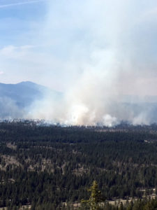 A burn on the Fussee pasture between Baynes Lake and Elko was planned by the Rocky Mountain Natural Resources Society. Lit on April 25, only half of the planned 600 ha were burned and did not achieve the objective of removing small trees and dead wood on the ground that can create fire hazards later in the summer. Hopefully the job can be completed later this autumn.
Prescribed burns provide important training opportunities for BC Wildfire Service staff and municipal fire departments. They get to work and learn together. Local fire departments can work in forested areas so they are better prepared to action interface fire events like this past weekend in Kimberley. City of Cranbrook firefighters joined BC Wildfire Service on the Fussee burn last month.
Prescribed burns are critical tool for managing our local open forests and grasslands. While it may seem counter-intuitive that fire is necessary to a forest, this is exactly the case for the East Kootenay valley bottoms.
The Rocky Mountain Trench – the broad main valley bottom that lies between the Rocky Mountains to the east and older Purcell Mountains to the west has historically been shaped by fire since emerging from the last Ice Age some 10,000 years ago.
The Trench ecosystems – a mosaic of open forests, grasslands and pockets of more dense, closed-canopy forests experienced fire every 10 to 15 years, on average over much of this time period. Often, these fires were lit by the Ktunaxa people to maintain open sightlines and encourage forage for ungulates.
The mature Douglas fir, ponderosa pine and western larch trees remained unharmed as the rapid, relatively cool fires swept quickly through the dead grass and scattered wood close to the ground. Bunch-grasses and fescues that provide essential forage to wildlife thrive on the frequent fire and quickly sprout lush new growth in its aftermath.
But since the mid-1940s we’ve been very effective at eliminating fire; too good. Douglas fir and lodgepole pine forests have grown thick and now in many places choke out light from reaching the forest floor. Dead wood accumulates on the ground and in the form of crackling dry tree limbs. Kindling for wildfire that is becoming increasingly common throughout western North America.
This leads to catastrophic wildfire like the tragedy we saw last year in Paradise, California. What managers are trying to do is avoid this coming closer to home in the East Kootenay.
Pre-planning for prescribed fire is extensive, thorough and professional. Prior to any burning, significant mechanical reductions in trees and dead wood on the ground takes place. Not every site is a suitable candidate for burning. Fuel breaks, both natural and manufactured, are identified and used to mark boundaries of where burns will be permitted to occur. In the rare instance that it occurs, any escape beyond these boundaries is immediately actioned and put out.
Once a site has been suitably prepared, the burn will still only occur when weather conditions are just right. As noted, this is typically in early spring before green-up or later in the fall. Conditions should be dry enough to carry the burn and achieve the desired combustion of fine fuels and regenerating young trees but not so crackling dry that any potential escape might threaten surrounding areas. Venting conditions that will carry smoke high into the atmosphere are important. But winds cannot be too high and a bit of rain in the following days’ forecast is always welcome.
Unfortunately, in many recent years, this Goldilocks zone of proper conditions hasn’t been met. The rapid transition from late winter to early summer where temperatures jump from near or below freezing to high teens is not conducive to prescribed burns. Climate change is perhaps better termed “Climate Weirding” where extreme weather becomes the new normal.
This spring, conditions didn’t line up properly. Managers and fire professionals are not going to willy-nilly light up a burn just for the sake of doing so. What is required is the planning and preparation to ensure that when conditions are right, crews must be ready to mobilize and take advantage of the opportunity.
Evidence from multiple sources suggests that the smoky summers of the past two years may be more common for western provinces and states. Prescribed burns in the East Kootenay Trench are not going to eliminate that. Smoke can travel hundreds of kilometres so unfortunately there’s little that can be done there.
However, the protection afforded to our communities and rural homes is very real. Thinning forests in the interface surrounding Cranbrook, Kimberley and other East Kootenay municipalities is essential to reducing risk. The benefits to local ecosystems, for wildlife and agriculture is just as significant.
All in all, the positives to prescribed burning are too great to ignore. We choose not to use it at our peril.
Above images: The Fussee burn that took place on April 25, east of Baynes Lake. Photos submitted

