Home »

Roads added to White River Complex closures
For reasons of public safety, the BC Wildfire Service (BCWS) is implementing additional road closures around the White River Complex wildfire, which is burning about 47 kilometres northeast of Canal Flats in the Southeast Fire Centre.
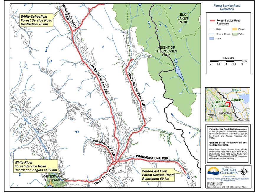
The additional road closures are in effect as of Aug. 21, for:
* the White-Schoefield Forest Service Road, starting at the 78-kilometre mark;
* the White River Forest Service Road, starting at the 32-kilometre mark;
* the White-East Fork Forest Service Road, starting at the 60-kilometre mark.
These are complete road closures, meaning that these roads are off limits to all traffic apart from firefighter and first-responder vehicles. The closures are intended to help protect public safety and provide unhindered access for firefighters and their equipment.
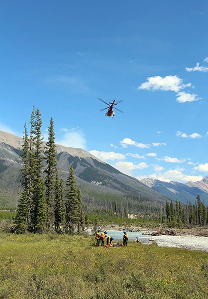
The White River Complex wildfire includes the White River wildfire (about 1,214 hectares) and the Grave Creek wildfire (about 2,013 hectares), which are burning about 15 kilometres apart. Together, these two fires cover about 3,227 hectares.
The White River Complex wildfire is listed as a Wildfire of Note on the BC Wildfire Service website.
As far as the other wildfires in the region, the Island Pond fire is no longer a wildfire of note, according to the BCWS.
The Quinn Creek fire, located three km east of Top of the World Provincial Park, started by lightning on August 10, is now at 411 ha.
And the lightning-caused White Creek-Monitor fire, started on August 11, remains at 30 km. This fire is located in the high country between St. Mary’s Alpine Provincial Park and the Purcell Wilderness Conservancy, about 25 km northwest of Kimberley.
Finally, the largest and longest-burning wildfire, the Verdant Creek fire in Kootenay National Park and Mount Assiniboine Provincial Park, is now at an estimated 15,550 ha.
Started by lightning on July 15, the fire has been contained to the western side of the Continental Divide, away from nearby Sunshine Village and the Banff-Canmore Bow Valley corridor.
Due to recent rainfall and cooler temperatures – and in consultation with the BC Wildfire Service – BC Parks reopened portions of Mount Assiniboine Provincial Park for public use on Wednesday, Aug. 16.
Members of the public will once again be able to use:
* the north core area around Sunshine Meadows, including the Standish viewpoint and access trail, the Rock Isle loop and the Grizzly-Laryx Lake trails;
* the south area, including the Upper Simpson Drainage south of Og Lake and the extreme upper portion of the Mitchell River drainage (Cerulean, Sunburst and Elizabeth lakes and trails);
* the Assiniboine Creek drainage.
Areas still closed in Kootenay National Park include: area northwest of Honeymoon Pass Trail including Hawk Creek Trail; Verdant Creek and Simpson River area; and the southwestern portion of the Vermilion Valley.
The Southeast Fire Centre extends from the U.S. border in the south to the Mica Dam in the north and from the Okanagan Highlands and Monashee Mountains in the west to the B.C.-Alberta border in the east. The Southeast Fire Centre includes the Selkirk Natural Resource District and the Rocky Mountain Natural Resource District.
To report a wildfire or open burning violation, call *5555 on a cellphone or 1 800 663-5555 toll-free. For the latest information on current wildfire activity, burning restrictions, road closures and air quality advisories, visit BCWS website or Parks Canada’s website for Verdant Creek wildfire updates.
Lead image: A water bomber his the Lamb Creek fire, earlier this month. Linda Botterill photo
e-KNOW