Home »

Three fires threatening regional communities

Wildfire Update for the East Kootenay (July 25)
Three wildfires of note are threatening East Kootenay/Ktunaxa Nation communities today.
The Bruce Mountain Wildfire (formerly called Horsethief Creek) has grown to an estimated 300 hectares and has forced an evacuation order and alert for 25 homes and 1,041 homes.
Since discovery Monday, July 24, this wildfire has been displaying aggressive rank 3-4 fire behaviour, which is moderate to highly vigorous surface fire with occasional candling and an organized flame front, BC Wildfire Service (BCWS) reported this morning.
With this level of fire activity combined with strong gusty winds, it continues to be beyond aviation resources at this time. Given the mountainous terrain, strong winds, and current level of fire activity, it is unsafe for ground crews to directly attack the fire and indirect strategies are going to used.
Weather is forecast to remain warm and dry on Tuesday, with gusty winds continuing.
On Tuesday, aviation resources and heavy equipment are responding to this fire. Aircraft include three heavy-lift helicopters and two “scoopers,” purpose-built aerial firefighting aircraft capable of holding up to 1,200 gallons of water.
Structure protection personnel are on site to conduct assessments and install equipment as required in areas of potential concern.
This fire will continue to be highly visible into the evening and through Tuesday as strong winds are forecast to continue.
The fire originated approximately seven kilometres north of Panorama Mountain Resort and 10 kilometres west of Invermere.
The Regional District of East Kootenay has issued an evacuation ORDER and ALERT.
 The Lladner Creek Wildfire straddling Sparwood Ridge, is now an estimated 150 ha.
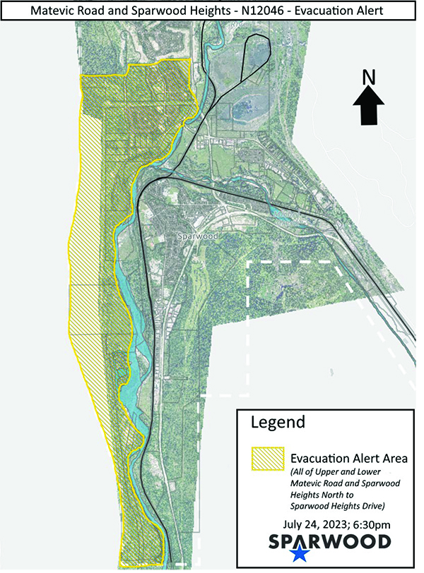
An Evacuation Alert has been issued by the District of Sparwood due to threat from the Lladnar Creek Wildfire and the potential danger to life and health for the residents within the District of Sparwood as outlined on the attached map for the following properties:
– All properties on Upper and Lower Matevic Road;
– All properties in Sparwood Heights, south of Sparwood Heights Drive.
Discovered on Friday, July 21, the lightning caused fire remains out-of-control.
Weather is forecast to remain hot and dry on Tuesday, with winds of 30 km/h gusting up to 50.
Fire behaviour remained elevated overnight as winds continued to push the fire downslope burning at rank 1-2 with pockets of rank 3 in areas with heavy fuel accumulation. Learn more about wildfire rank.
On Tuesday, heavy equipment and firefighters are putting in machine guard along the BC Hydro right-of-way at the bottom of the slope. Crews are preparing water-delivery systems and establishing hose-lay in critical areas.
Human life and safety remains the BC Wildfire Service’s number one priority.
Aircraft will be flying the fire on Tuesday. The fire has moved further downslope and heavy equipment and firefighters are constructing machine guard and wetline to help prevent spread toward the community. Helicopters are on site and will bolster those efforts where it is safe and effective to do so.
While wildfire management relies on a fleet of reliable and capable aircraft to assist firefighters on the ground, there are several incidents where the use of aircraft can have unintended negative consequences. It is the job of experienced personnel on the ground, in the zone, in operations, and in aviation to decide whether the use of aircraft would do more harm than good. With ground crews available to help mitigate potential negative impacts, officers will determine how to best use available aviation resources to assist in fire suppression.

The St. Mary’s River Wildfire is still being reported at 4,093 ha and holding.
“Weather is forecast to remain hot and dry on Tuesday, with winds of 30 km/h gusting up to 50.
“Control lines have continued to hold and no growth was observed overnight from Monday night through Tuesday morning. Despite strong gusty winds, fire behaviour has remained a smouldering ground fire,” BCWS said.
“The operational priorities remain unchanged: detecting and suppressing hot spots and removing unburnt fuels through small-scale planned ignitions. Crews and heavy equipment will continue overnight shifts to patrol, monitor and continue mop-up.”
There are seven aircraft assigned to this incident, including two heavy-lift helicopters. Rotary wing (helicopter) resources will be continuing to support the fire throughout the day as visibility and daylight allows. Ground crews and aviation are working in tandem to detect and suppress hotspots as they are discovered during the day.
The heavy equipment teams have completed work on additional contingency guards to the west and north.
Evacuation Orders and Alerts
Evacuation ALERTS and ORDERS for The ʔaq’am community have been updated as follows.
The Regional District of East Kootenay has an evacuation ALERT in effect as follows.
The City of Cranbrook has implemented an evacuation ALERT for the Canadian Rockies International Airport.
The Village of Canal Flats has two fires in its vicinity.
A wildfire discovered July 24 in Mia Creek, about 18 km east of Canal Flats, is now an estimated 400 ha. The lightning-caused, out-of-control fire was discovered on July 24. It is receiving a full response.
The BC Wildfire Service uses a full response when there is threat to public safety and/or property and other values, such as infrastructure or timber. Immediate action is taken. During a full response, a wildfire is suppressed and controlled until it is deemed “out,” BCWS explained.
And there is a new fire visible from the village on Fur Mountain, 11 km northwest of Canal Flats.
Discovered this morning (July 25), the fire is an estimated .009 ha.
The out-of-control, lightning caused fire is receiving a full response from BCWS.
The lightning-caused fire discovered July 19 in Kamma Creek, about 25 km west of Lumberton, remains out-of-control at 113 ha.
It is receiving a full response.
A lightning-caused wildfire discovered July 9 in Yearling Creek, 25 km east of Radium Hot Springs, has ballooned out-of-control at to 1,150 ha.
A wildfire in Vowell Creek, about 13 km northwest of Bugaboo Provincial Park, discovered on July 22, is 4.2 ha. The lightning-caused fire is out-of-control.
There are also three wildfires burning in the Beaverfoot Range north of Spillimacheen and east of Parson.
The lightning-caused Castle Mountain wildfire, about six km northeast of Harrogate, remains out of control at 15 ha.
A new wildfire has been discovered today at Ice River, which flows into Beaverfoot River Valley. The lightning-caused fire is out-of-control at .009 ha.
The third of the fires in the Beaverfoot is at Birchlands Creek, about 11 km southeast of Nicholson. Discovered on July 23, the fire is an estimated 0.3 ha.
Lead image: The Bruce Mountain Wildfire. BC Wildfire Service photo
e-KNOW