Home »

Area restriction in effect for Raymond Peak Wildfire
The BC Wildfire Service has implemented an Area Restriction Order for the vicinity of the Raymond Peak wildfire (N12589), which originated approximately 15 kilometres southeast of Elko.
This area restriction reflects the need to protect the public in areas where fire suppression activities are taking place.
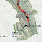
This restriction takes effect immediately and will remain in effect until noon (PDT) on October 15, or until rescinded. The order applies to Crown land within the geographic boundaries described below and outlined in the provided map.
Area Restriction Order details:
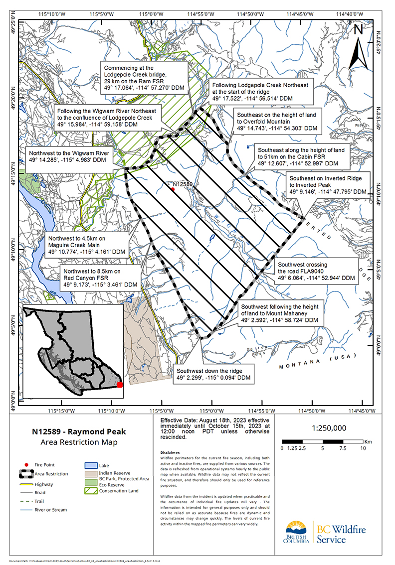
Commencing at the Lodgepole Creek bridge, 29 km on the Ram FSR [49° 17.064′, -114° 57.270′],
Following Lodgepole Creek northeast at the start of the ridge [49° 17.522′, -114° 56.514′],
Southeast on the height of land to Overfold Mountain [49° 14.743′, -114° 54.303′],
Southeast along the height of land to 51km on the Cabin FSR [49° 12.607′, -114° 52.997′],
Southeast on Inverted Ridge to Inverted Peak [49° 9.146′, -114° 47.795′],
Southwest crossing the road FLA9040 [49° 6.064′, -114° 52.944′],
Southwest following the height of land to Mount Mahaney [49° 2.592′, -114° 58.724′],
Southwest down the ridge [49° 2.299′, -115° 0.094′],
Northwest to 8.5km on Red Canyon FSR [49° 9.173′, -115° 3.461′],
Northwest to 4.5km on Maguire Creek Main [49° 10.774′, -115° 4.161′],
Northwest to the Wigwam River [49° 14.285′, -115° 4.983′],
Following the Wigwam River Northeast to the confluence of Lodgepole Creek [49° 15.984′, -114° 59.158′],
Northeast following Lodgepole Creek to the point of commencement at 29km on Ram FSR and the Bridge over Lodgepole Creek
Note: Access to the Wigwam River is permitted; entering into the restricted area off the river is prohibited.
Under this Order and section 11(2) of the Wildfire Act, a person must not remain in or enter the restricted area without the prior written authorization of an official designated for the purposes of the Wildfire Act, unless the person:
1) First receives written authorization of an official designated for the purposes of the Wildfire Act, or
2) Enters the area only in the course of:
travelling to or from his or her principle residence that is not under an evacuation order;
using a highway as defined in the Transportation Act;
travelling as a person acting in an official capacity as defined in s.56 of the Wildfire Act; or
travelling for the purpose of supporting wildfire suppression or enforcement patrol activities.
The BC Wildfire Service reminds the public that although access to a private residence is permitted, the public must stay out of active fire areas. Public interference has a direct impact on the effectiveness of fire suppression activities and poses safety risks to both the public and responders who are working to contain the fire.
This Order is subject to and subordinate to any applicable evacuation orders made under the Emergency Program Act. Failure to comply with Section 11 restricted area requirements may result in a violation ticket of $1,150.
The out-of-control Raymond Peak Wildfire was discovered August 6 and is now 1,909 hectares, as of August 19.
Road closures and area restrictions are subject to change depending on fire activity. For the most current information please visit the bans and restrictions section of the BC Wildfire website for the Southeast Fire Centre, or visit: https://ow.ly/3UJo50Kc3o3
To report a wildfire, unattended campfire or open burning violation, call 1-800-663-5555 toll- free or *5555 on a cellphone. For the latest information on current wildfire activity, burning restrictions, road closures and air quality advisories, go to: www.bcwildfire.ca or download the BC Wildfire Service public mobile app.
BC Wildfire Service map
e-KNOW