Home »

Elk Valley Trail (Trans Canada Trail) update
By Robert Champagne
Once again, it’s great to see the progress that’s happening on the Trans Canada Trail all the way from Round Prairie (just north of Elkford) to Elko. What a great collaboration of the communities in the Elk Valley! Here are some of the highlights, broken down by sections.
Round Prairie to Elkford
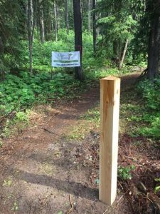
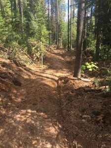 Authorization for significant re-routes and upgrades to the Mountain Walk Trail was granted by the BC Recreation Sites and Trail Program, Rocky Mountain District. 2.3 km of new trail has been constructed by Cornerstone Excavating to bypass the central section that was damaged by motorized use. It is looking great and will make for a high quality cycling trail once the remainder of the Mountain Walk upgrades have been done. Cabin Forestry will be doing the remainder of the upgrades and re-routes on this trail. The south end will require a re-route to straighten out the alignment and bring the grades down to the target 10%. The north-central section is already a great bike trail and only needs minor upgrades and a few short re-routes to bypass steep gully sections. The north end of the trail at Round Prairie has been affected by logging, blow down and flooding in Crossing Creek and will need some significant work as the trail is not even discernible in many spots. Layout and planning of work in this section is complete and work is scheduled to begin in September. Users of this trail are requested to respect the non-motorized designation of the Trans Canada Trail. New trail sections are still soft and are particularly vulnerable to damage from motorized use. This is currently being addressed through signage, community notifications, and word of mouth via the Elkford ATV club.
Elkford to Line Creek
 A land use agreement is in place for establishment of this section of the Trans Canada Trail, which is located on private property owned by Jemi Fibre.
Approximately 1.8 km of new trail will be constructed on the east side of the Elk River to connect Elkford with the Sulphur Springs forest road. Cabin Forestry will be completing this section starting in late September and October.
A new route is being developed that will utilize 3.5 km of existing low use forest road combined with approximately 2.75 km of new trail between the Elk River and the main Sulphur Springs forest road. This route will pass by the Sulphur Springs, an interesting natural feature. Planning and layout work is still underway in this section.
Line Creek to Sparwood
Heading south from the Line Creek Road the Trans Canada Trail will follow a three km section of Highway 43 as well as most of Lower Elk Valley Road. Permission from Teck was recently granted to construct a 3.8 km section of new trail on their property north of Wilson (Cummings) Creek just outside of Sparwood. This is excellent news as this will make for a wonderful section of trail through a beautiful natural setting on open bench lands next to the Elk River. Planning and layout work on this section will be occurring over the next few weeks.
A full scale upgrade to the Cypress trail within the District of Sparwood is underway, with the trail work being done by Elk Valley Excavations. This trail is partially open now and should be fully completed in the near future. Elk Valley Excavations will also be constructing the 1 km Whiskey Jack frontage trail that will connect the Cypress Trail to the Wilson Creek Bridge.
Sparwood to Hosmer
Approximately 4.5 km of trail upgrades and approximately 700 m of re-routes have been completed by Cabin Forestry on the Coal Discovery Trail (CDT) south of the Sparwood Campground. Work is progressing on 1.7 km of new trail construction to connect the existing trail with Black Diamond Creek.
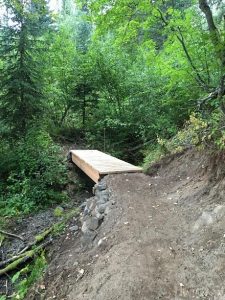
The District of Sparwood and the NCC (Nature Conservancy of Canada) have an existing Land Use Agreement for a section of the Coal Discovery Trail located within their Elk Valley Heritage Conservation Area. NCC has authorized the re-route of an existing steep section to reduce ecosystem degradation (poor drainage and erosion) and improve trail standards, resulting in a net increase of approximately 385 m of trail. A new trail section will also be developed that will go behind the expanded Wilson Lake gravel quarry, reconnecting the north and south ends of the CDT. In total this work involves 2.1 km of new trail construction and 1.1 km of upgrades to existing trail. As part of this work, the new but now redundant foot bridge at Hosmer will be relocated to cross Ingham Creek.
It is hoped that the privately owned deactivated road that connects the north end of Stephenson Road with the BC Hydro Powerline at Hosmer, which is the CDT in this area, can be reactivated to become part of the Trans Canada Trail. By bringing the trail down off the power line and into Hosmer, there is an opportunity to provide a good access point from Highway 3. The trail would also pass by the historic coke ovens which would be an interesting historical feature for people traveling the trail. A trailhead kiosk explaining the coal mining history and map would be installed in this area. A proposal for this work is currently under review by the landowners.
Fernie to Hosmer
 Active forest harvesting is occurring on Jemi Fibre property along the Coal Discovery Trail between “Porky Blue” Creek and Fernie. Harvesting should be complete in this area by the end of August and restoration work on the three to four km of affected trail is scheduled to take place in September and October by DIG Trail Design.
Upgrades to the three km section of the CDT closest to Fernie that will not be affected by forest harvesting will occur in September with Mow and Snow doing the work.
Morrissey to Fernie
The 1.3 km old Fernie landfill bypass trail, has been constructed by Parastone Developments and is now open to the public. This new trail has nice views and is a great alternative to the Coal Creek Forest Service Road for accessing the trail system in the Montane and Castle areas. Drainage and culvert work on the existing Montane trail will be completed by Parastone later this fall.
The new section of the Montane trail (1.3 km) has been completed by Parastone Developments and is also open to the public. It is a great section of trail to cycle or hike, wide and beginner-friendly and it is already receiving lots of use. Good progress has been made on the 1.6 km of new trail connecting the Roots trail to the old Branch H road by Backcountry Trail Experts and this section is expected to be complete and open to the public by the middle of next week. This trail section also provides good access to the lower section of the existing Southern Comfort Trail. Planning and layout for a five km section of new trail to connect the Branch H road to Cokato Road south of Fernie is currently underway. Originally this trail was going to be located downslope of River Road Extension but the alignment has recently been adjusted to terrain upslope of this road due to the presence of three major gullies that would present significant challenges to trail construction. Backcountry Trail Experts will be starting the northern section of this trail this month. Considering the length of this section it is anticipated that a second trail crew will be deployed on this section, working from south to north, in order to get it done before the snow flies.
Elko to Morrissey
Sarah Meunier from Trans Canada Trail has arranged for permission from BC Hydro to use access road to the Elko Dam for the TCT – a license of occupation is in the works. A few challenges have been encountered regarding the trail alignment in the section from Morrissey through to the Mount Broadwood area.
There are several options that are being discussed presently and the outcome will surely be favorable.
Happy trails to all of you! I’m not sure about you, but I certainly look forward to riding all of these great new trails!